Using remote sensing to improve wildlife connectivity in Tanzania’s agricultural corridors
Pablo Cisneros-Araujo and Miguel Ramirez-Lopez, two former MSc students linked to the Development Corridors Partnership (DCP) from Copenhagen University, share their experience of working with the DCP in Tanzania. Their collaborative work resulted in the publication of this scientific paper in the journal Remote Sensing in Ecology and Conservation.
The search for research with practical, real-world implications
While following the Masters of Geoinformatics at the University of Copenhagen (Denmark), we were on the lookout for a thesis project that would allow us to apply our GIS and remote sensing skills towards conservation objectives. We also wanted to produce results that would be practically useful for land-use planners and various decision-makers. This is when we contacted Prof. Neil Burgess, Chief Scientist at UNEP-WCMC and Principal Investigator for DCP. He suggested we could collaborate with DCP on our project, and we were immediately hooked. With the guidance and support from UNEP-WCMC and the other DCP partner organizations, particularly Diego Juffe Bignoli (UNEP-WCMC), Prof Japhet Kashaigili (SUA) and Prof Pantaleo Munishi (SUA), we embarked on our exciting thesis journey.
What is a ‘development corridor’?
A development corridor is a geographical area identified as a priority for investment, to catalyse economic growth and development. This is usually through the creation of infrastructure such as road, railways or pipelines. They can be designed to attract new investments, boost agricultural production, open access to natural resources and facilitate their export to world markets.
The DCP carries out research and outreach activities to help in the decision-making around development corridor planning and management, providing a robust scientific evidence and encouraging stakeholder engagement in East Africa.
The Kilombero river catchment, Tanzania
We decided to focus on the SAGCOT (Southern Agricultural Growth Corridor of Tanzania), specifically on its Kilombero ‘cluster’, as this part of the agricultural corridor is an important site for biodiversity, hosting one of the largest freshwater wetlands in Africa. This region is also fundamental for elephant connectivity, located between the Selous and Ruaha ecosystems, the two most important elephant populations in Tanzania. The previously abundant natural wetlands and grasslands offered a suitable landscape for elephants to migrate between habitat areas, allowing them to reach new shelter and food sources and enhancing their adaptability to new threats.
In the last decades, much natural cover here had been converted into agricultural and grazing lands, but the Kilombero cluster was still in its planning stages, giving us the opportunity to produce useful connectivity information for project planning, minimizing further impact on critical elephant corridors.
Our research approach included creating a detailed land cover map
Along with Prof. Rasmus Fensholt and Dr. Javier Muro of the Center for Remote Sensing of Land Surfaces (University of Bonn), we produced a land cover map to characterize this landscape. We used image composites produced by combining multiple satellite images to make a classification model for the land and tree covers on this landscape. These image composites allowed us to capture the diverse stages of wetlands and other habitats, and we created a highly accurate land cover map that included 12 different classes with 20 m resolution. We then divided the landscape into sixteen habitat types, combining our land cover map and supporting spatial datasets.
A visit to Kilombero to understand the context on the ground
Our next step was to visit Kilombero to gather enough information to validate our maps, to correct possible classification mistakes, and to learn about the socioecological context of elephant connectivity. We were greatly supported by DCP partners at Sokoine University of Agriculture (SUA) and with NGOs and institutions working in the area (AWF, STEP and UEMC). All of them carefully explained and showed us many relevant aspects and nuances that were extremely useful for the project.
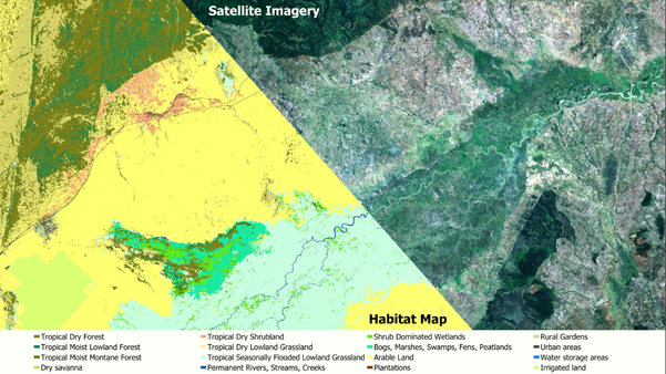
A map showing the Kilombero valley floodplain through Sentinel-2 satellite imagery (right) and the resulting habitat map (left) after the classification process. Created by the authors of the paper.
Using the primary data to identify the priority areas for elephant connectivity
After fieldwork, we conducted an elephant connectivity analysis in collaboration with María Cruz Mateo of (Universidad Politécnica de Madrid). We applied ‘least-cost modelling’, which essentially predicts the corridors that imply the minimum movement effort for elephants between two suitable habitat areas.
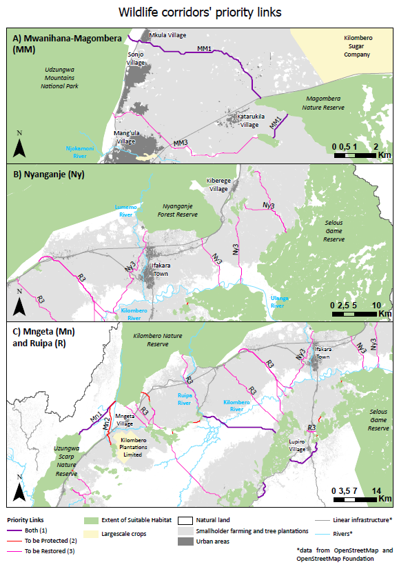
Afterwards, using a probability analysis (detailed in the paper), we prioritized the corridors according to two scenarios. First, according to their current contribution to connectivity and second, to their potential contribution to connectivity if each elephant corridor was fully restored (as some areas were quite degraded by this point). Both scenarios allowed us to identify the priority elephant corridors to protect for conserving connectivity (first scenario) and those to restore in order to recover elephant connectivity that had been lost (second scenario).
Results show how elephant connectivity over the Kilombero landscape can be prioritized
Our findings suggested a low functionality in the elephant connectivity network of the Kilombero region. However, this situation can be reversed by promoting restoration initiatives. For instance, restoration measures applied in the Magombera-Mwanihana and Nyanganje corridors could immediately improve the connectivity through the Kilombero floodplain.
New Tanzanian regulations could offer much-needed protected status for elephant corridors
Under these new Tanzanian regulations, many important elephant corridors could be promptly protected. For instance, the Mngeta corridor and those connecting the Ngapemba wetlands. Their protection can be achieved by using the new regulations to designate wildlife corridors as protected figures, among other useful alternatives.
However, cooperation between communities, NGOs and protected area authorities throughout the process is paramount. Our results are useful for planning mitigation or restoration measures (e.g. road crossing points) within pre-planned SAGCOT projects, to reduce or avoid potential impacts to wildlife corridors without compromising socio-economic development.
This type of remote sensing analysis offers targeted information for land use planners in Tanzania and beyond
Spatial data from remote sensing is increasingly available freely and globally, and methods for their processing to produce useful information for guiding nature conservation are improving rapidly. Our study demonstrates that the combination of multispectral and radar data can help biodiversity and connectivity management, and we hope it will encourage conservationists to assess ecological connectivity in different regions and for other species in need of conservation. This is especially relevant in planning agricultural projects for low and middle-income countries, as methods such as the one we have used can provide ready-to-use information for informed decision-making.
For more details, see the publication
Explore the data further, and download the map layer developed by the researchers, by visiting the DCP Online Data Portal:
Take a closer look at the corridors right here, with our interactive map below!
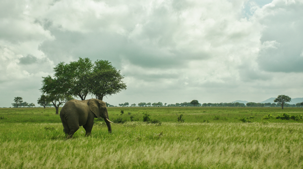
(Cover Image: An elephant grazing in a natural savanna in Mikumi National Park. An example of the previously abundant habitats in the Kilombero valley where elephants could feed and move freely. Image by Pablo Cisneros.)